Masonic Temple Site
Ground Once Known by Name of Seven Oaks
And Other Designations
When the Section Had the Aspect of Country District
Stream through 13th Street
Section Now to Become the Center of Interest of Masonic Fraternity
The erection of the Masonic Temple at the intersection of New York avenue, 13th and H streets will give a new name to that locality, and in the course of a few years Masonic Temple will have as general use in designating that section of the city as had the “Seven Oaks” of a hundred years ago and “Cover’s Tan Yard” or “Parson Baker’s Church” of a later period. When these names applied there was not in the wildest imagination an idea that such a building would ever grace this spot.
At the beginning of the last century, when there was but one lodge in the city, Federal No. 1, and that working under the Grand Lodge of Maryland, what is now to become the Masonic center of the District would have made a fit subject for an artist whose forte was country scenery. A stream of water meandered down 13th to a point south of H street, then turned eastward and from east of 10th street toward the old Tiber creek. A knoll, which included the southwest corner of 13th and H streets, denuded of its trees save seven noble oaks, overlooked the stream, hence the name “Seven Oaks.”
Some of the street beds had been cleared of trees and plants sufficiently for limited use, and prior to the twenties but few improvements could be seen. Northward the land had a gentle rise to south of K street, when the hill arose, on which Franklin row now stands. A story and a half frame set back in a garden at the southeast corner of 13th and L streets was known as Davidson’s and from a spring here the water flowed down 13th street, taking in the waters from springs on Franklin square and the street.
By 1820 there was an improvement on the north side of New York avenue between 12th and 13th streets, Mr. S. Siousa erecting a dwelling, assessed at $700, the ground being valued at 4 cents per foot. Southward facing the temple site were then small houses owned and occupied by David Jones, Betsey Fletcher and Joseph Calder, assessed, respectively, $120, $80 and $300. At the corner of 13th and G streets were the homes of Samuel Clokey and William Heron, each dwelling two-story frames, valued at $500 each. There were a few houses on G street, the Clephanes, James and Lewis, near 13th street. Walter Steward at the southwest corner of 12th street, and Rev. Daniel Baker in one of three two-story bricks on 12th street north of G street.
Site of a Church
Directly west and on a similarly shaped site was the then new Second Presbyterian Church, popularly “Parson Baker’s.” This congregation is now the New York Avenue Church, but the edifice then was a small chapel. West of the church was Thomas Snowden. One cent per foot was the corporation valuation of the ground.
On the south side of New York avenue were two or three two-story brick houses, owned by John McClelland, who lived in one of them. The Foundry meeting house, on the present site of the Colorado building, was the name of the Foundry M. E. Church at that day.
The ground in this square was valued at 3 cents per foot, and held by Davidson heirs, R. Harrison, D. Bussard, B. Fenwicks’ heirs, E. Dimmick and others. There had been but little improvement.
The square where the temple will be erected was in the early days held in the name of John Davidson and assessed at 4 cents per foot. The fact that it was situated north of the stream referred to and a portion of it low ground, doubtless prevented the early sale of lots there. H.H. Chapman appears to have owned lots 10 and 12 on 12th street, between H street and New York avenue in 1803, when they were transferred to Thomas Snowden, and there do not appear to have been any improvements till in the twenties.
In 1822 there was a lease made by Mrs. Chapman of lots 4 and 9, the west end of the square, to John Carothers, a tanner, on C street between 11th and 12th streets. This lease was assigned by him to Mr. George Cover a few months after, and he subsequently acquired full title. It included the whole New York avenue front of the square.
In 1830 lots on 12th street were held by C. F. Wood and Joseph Bryan, carpenters, and in 1823 the corner of 12th and H streets, was bought by George W. Stewart, who established a grocery, liquor and feed store, to which, after purchasing other lots, he added a wagon yard, which in the forties was a leading establishment of the kind. Others who were interested in the square were Charles L. Coltman, Andrew Small, Lambert Tree and John Coburn.
There was a tanyard there for nearly half a century – the vats being supplied by the waters from the stream before mentioned, the lower part of which, in after years, was known as Sluice run. It was long under the management of Daniel Cover. Mr. George Cover soon after erected a row of brick dwellings on New York avenue, which was known by his name. The tannery was an object of interest, especially to the boys of that day, and soon “Cover’s tanyard” helped to designate the locality. As the population increased it became a meeting point for the youngsters.
Franklin Row Built
The erection of Franklin row on K street between 12th and 13th streets in the thirties gave some impetus to some further improvements, which came gradually. There were some improvements of a public nature, but so little had been done in the streets that there was still the country aspect about this locality. There were in 1840 some brick pavement with bluestone curb and cobble-stone gutters on the street, and the waters referred to flowed in full view. At some points a simple bridge was provided by the corporation or by private parties.
Some improvement had been made in this square. Besides the tanyard and Cover’s row there were at the corner of New York avenue and 12th street the carpenter shop of David ___ Gardner, and on New York avenue that of Isaac Cooper, with his residence. On H street were the houses of Hex Sipe and W. Smith, the latter an engraver. The southern portion of the square east of H street between 11th and 12th streets was devoted to the flower garden and green houses of Henry Buist. At the northwest corner of 12th and H streets was the grocery of George W. Stewart, as well as a wagon yard for country people. At the northwest corner of 12th street and New York avenue the store of the Ager Brothers was located. They removed to a point east of 11th street and were succeeded by Michael Talty; Henry Ould’s School, as the public school was known, located at 14th and G streets, a little later became Henshaw’s. John Wilson, long commissioner of the land office, had erected a brick dwelling on New York avenue opposite the Presbyterian Church, and nearby lived William Selden, United States treasurer, while opposite his home was that of Maj. J. H. Riely, who was prominent in the District of Columbia militia. Columbus Alexander was on the 14th street south of New York avenue. A flower garden occupied about half of the square fronting H street between 11th and 12th streets, and was conducted by Henry Buist. A row of frame houses west of Talty’s store was known by his name, and farther west was the home of John H. Plant, in “Plant's row” of two-story brick dwellings, which are standing today. Two or three brick dwellings, one occupied by John F. Hartley of the treasury, were on 12th street.
The frame structure used by the present Rhode Island Avenue Methodist Protestant congregation early in the thirties, located south of H street on 12th street and known as the tabernacle, was later known as Weatherbee and Peugh’s school house.
Slye’s orchard, north of Franklin row, passed out of existence some time between 1845 and 1850, and Michael Jusia was cultivating the garden at what had been Davidson’s home, near 13th and L streets. There were some colored settlements in the vicinity – one of them on I street between 12th and 13th streets and another on L street north of Franklin square.
Evidence of Improvement
This will show that though progress in “de days befo’ de wa’,” there was improvement. But it must be confessed that the rapid strides made by this community in the past thirty years would bewilder the actors of those days, some of whom are represented in the business circles of today by their grandchildren.
Doubtless also, will some of the pioneers of the fraternity in this jurisdiction be represented by their lineal descendants in the splendid temple to be reared near the “Seven Oaks” landmarks on the vats where perchance lambskin was tanned in “Cover’s tanyard.”
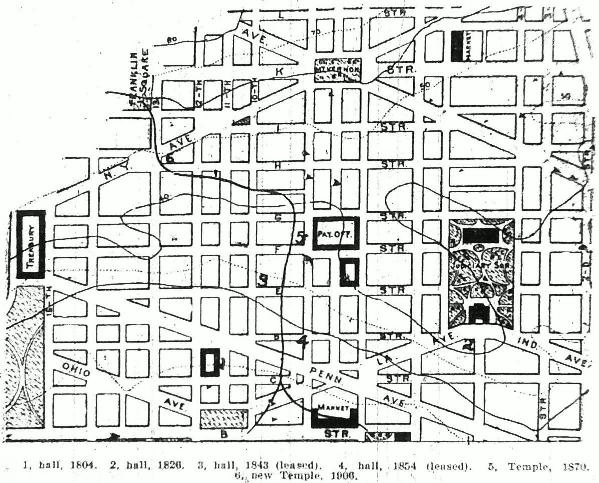
It will be observed that in the early years before emptying into the old Tiber, less than a hundred feet south of Pennsylvania avenue and west of 9th street, the stream passed within a few hundred yards of the halls of the fraternity. The first permanent site was on the west side of 11th street below the avenue, now covered by the general post office and the hall was used till the twenties. In 1826 the hall at the southwest corner of 4 ˝ and D streets was erected by four lodges. This building proved to be a burden, and litigation ensued between the lodges and a member and with other parties. In addition the membership was weakened by the anti-Masonic excitement, and in 1843 the lodges were ousted. The few faithful ones went into other quarters in various parts of the city.
The Grand Lodge and some of the royal chapters, with Federal Lodge, No. 1; Columbia Lodge, No. 3, and Lebanon, No. 7, located in the Medical College building, northeast corner of 10th and E streets. Here the grand bodies and some of the subordinates met till 1854.
New quarters were found at this time in the Keyworth building, southwest corner of 9th and D streets, and this was the meeting place till the present temple, at the northwest corner of 9th and F streets, was completed in 1870.